Casa Grande Ruins Trail
15 cents if you take this booklet home
CASA GRANDE RUINS NATIONAL MONUMENT
ARIZONA

SAFETY
You are in a desert area. Sometimes the desert can beharsh. Cactus spines can hurt. Intense heat can cause varyingdegrees of discomfort. Poisonous animals, though rare,are here. Know your own limitations, and exercise caution.
NATIONAL PARK AND MONUMENTS
Casa Grande Ruins National Monument, one of morethan 280 areas administered by the National Park Service,United States Department of the Interior, was set aside becauseof its outstanding archeological values. This area belongsto you and is part of your heritage as an Americancitizen. The men and women in the uniform of the NationalPark Service are here to assist you and will welcome theopportunity to make your visit to Casa Grande Ruins moreenjoyable.
The National Park Service was created in 1916 to preservethe National Parks and Monuments for your enjoymentand that of future generations. Federal law prohibitsactivities which would destroy any of the works of natureor man that are preserved here. These include such activitiesas hunting, woodcutting, collecting—even taking of smallpieces such as broken pottery. Please help preserve CasaGrande Ruins National Monument, and remember: Athoughtless act on your part can destroy in a few momentssomething that has been here for centuries. Please stay onthe designated trail.
DON’T FORGET YOUR CAMERA
Casa Grande Ruins Trail
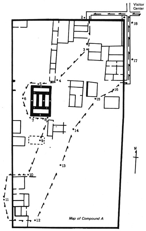
The Casa Grande Trail is about 400 yards long and aneasy walk. Numbered stakes along the trail are set at pointsof interest, and corresponding numbered paragraphs in thisbooklet explain the features.
You may enter the Casa Grande (Big House) only on aranger-conducted guided tour.
1.
From about 2,000 years ago until about A.D. 1450,people living in this area developed and expanded a stone-agecivilization that the archeologists call the Hohokam(Ho-Ho-Kahm) culture. Hohokam means “those who have2gone” in the language of the nearby Pima Indians, who areprobably descendants of these prehistoric people.
The Hohokam lived in this region for many centuries beforebuilding walled villages like this between A.D. 1300and 1450. Primarily farmers, raising corn, beans, squash,and cotton, they developed extensive irrigation canal systemsthat took water from the Gila (Hee-la) River. AboutA.D. 1450, this village and others like it were abandoned.We do not know why. When the Spaniards explored thisarea, they found Pimas, living in open villages and irrigatingtheir farmlands, several miles to the west.
2. Village Wall.
The wall around this village originallystood 7 to 11 feet high. There were no doorways in it. Thiswall and building of this village are of caliche, a limy subsoilfound 2 to 5 feet below the surface of this region. Toget in or out of the village the Indians used ladders to climbover the wall. The f